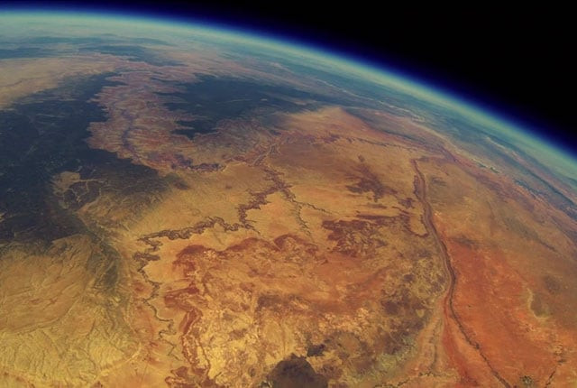
Recovered camera reveals stunning images of Grand Canyon from space
Almost nine minutes after being released, the balloon was 22,967 feet above the earth

YOUTUBE SCREEN GRAB
The group of aerospace engineers from Stanford University loaded a 3D-printed frame with a GoPro camera, mapped a course, attached a weather balloon and sent the camera into the skies, nearly 20 miles west of the Grand Canyon in Tuba City, Arizona.
 YOUTUBE SCREEN GRAB
The group also attached a GPS-enabled smartphone to ensure the recovery of the camera, and record the location of the balloon.
 YOUTUBE SCREEN GRAB
Almost nine minutes after being released, the balloon was 22,967 feet above the earth. By 23 minutes, its height was 37,916 feet, and after 72 minutes from an altitude of nearly 90,000 feet the camera was recording images of the American southwest from the sky.
Read: Asteroid will not destroy Earth next month: NASA
Despite all the arrangements, the team had no knowledge of the shooting and the balloon's location since they never heard from the device they had programmed to transmit the landing coordinates.
For nearly two years, the group thought they had miscalculated the course of the device and that it must have ended up in a dead zone preventing it from texting a GPS location.
 YOUTUBE SCREEN GRAB
It wasn’t until a hiker found the phone about 50 miles from the location of the liftoff, that the group received the footage. It turned out the group had never miscalculated the course but the AT&T service map used was inaccurate.
Once the group recovered the data, they got to know the balloon ride lasted an hour and 38 minutes and rose 98,664 feet before the balloon popped and sank back to earth. The footage revealed some incredible images of the Grand Canyon caught from the space.
Students launch a balloon with a @GoPro, 2 years later the footage was found. #GrandCanyon https://t.co/yKqH5a3l0q pic.twitter.com/q42M8Kbuxc
— Epic Cosmos (@EpicCosmos) September 11, 2015
This article originally appeared on Mentalfloss


COMMENTS
Comments are moderated and generally will be posted if they are on-topic and not abusive.
For more information, please see our Comments FAQ