Ravi River continues to erode land
Bank erosion causes change in river course, resulting in washing away of habitable areas

PHOTOS: EXPRESS
In the absence of legislation, the victims have nowhere to look to for their rescue. Although the province hosts several courses of rivers including Indus, Jhelum, Chenab and Sutlej, the 720-kilometre long River Ravi flows from Dara Rotang point in Kangra district, just adjacent to the provincial capital.
The area between Ravi and Chenab is referred to as Doaba Rachna. The Ravi was earlier known as Irawati. However, this river no longer has the strength to flow throughout the year. The water released from India and suspension of rains and canals in ordinary course has affected the flow from Ravi River. Reportedly, the river’s water level is on a gradual decline and its high banks are also being expanded and taking up nearby land. Due to this, even a small volume of water flow can turn into a flood.
It is typical of Ravi to erode the land and change its course even with a weak flow of water. The erosion of the river banks means that the river’s course will be altered and water will flow to high-elevation areas. The erosion rate can sometimes be so high that its flow washes away hundreds of acres of land and villages within a year.
India pursuing ‘water offensive’ against Pakistan
At the point of Kamalia, the river gains about 200 to 250 cusecs owing to the influx of water from Saim nullah in the provincial capital.
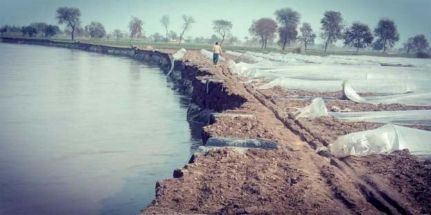
In the last few decades, overflow and change of Ravi River’s course has taken over space of several settlements. The brutal erosion from the river has deserted several villages including Mahabat Basti, Khar Lanawala, Takra, Jhalar Sughla, Haweli Tara, Mil Futiana, Khan Da Chak, Shahabal Shah and Sandhilianwali. Determining the field area of Ravi is near to impossible as the river does not flow in a single direction. At times, the river changes its course several times within a span of one kilometre. The land eroded from the river is not counted as part of the river’s field and, instead, as deserts. The erosion from Ravi has caused changes in the distribution of the agricultural land surrounding it.
The erosion process continues incessantly over the year and continues to eat up habitable land. In the last few decades, thousands of acres of agricultural land have been lost to erosion from Ravi River while parts of land with 15 to 20 feet of standing crops have also been eroded.
There are hundreds of people who once used to carry out farming in the land adjacent to Ravi but now they have lost both their land and their homes to the expansion of the river bed.
The government continues to be negligent to the issue even as the situation became more alarming in present times than it was in the past. There is an increased risk of flooding in areas with elevation as low as 25 feet from the river including Kamalia, Pir Mahal, Shorkut, Sandhilianwali and Uroti tehsils.
Published in The Express Tribune, February 22nd, 2020.


MOST READ

Trump announces end of Iran naval blockade, says now making 'final determination' on deal

Punjab CM undergoes major surgery in Lahore, returns home: Marriyum Aurangzeb

Severe heat persists in Sindh as Karachi records humid conditions

Govt slashes petrol, HSD by Rs22 in 'Eid gift' for people

PMD predicts rain, thunderstorms in parts of Sindh


COMMENTS
Comments are moderated and generally will be posted if they are on-topic and not abusive.
For more information, please see our Comments FAQ