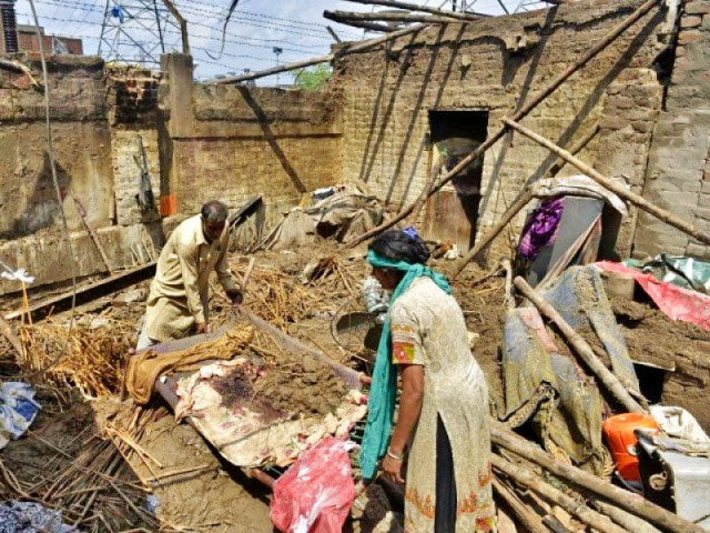
Widespread devastation: Officials blame illegal settlements on riverbeds, banks
Displaced villagers complain of inadequate compensation

Widespread devastation: Officials blame illegal settlements on riverbeds, banks
The key districts affected by September’s floods in South Punjab include Okara, Sahiwal, Khanewal, Multan, Vehari, Layyah, Muzaffargarh, Bahawalpur, Rajanpur and Rahim Yar Khan.
Layyah
Lying on the banks of the River Indus in Dera Ghazi Khan division, Layyah has always been affected even by low-level flooding. In May, the first warning of floods and calls for early preparation are given by the provincial government for this district. This year, the district government had prepared a ground report, which was sent to the flood monitoring centre in Lahore and the provincial government stated that it was satisfied with preparations for the expected floods.
However, locals disagree. “The government claims that it has made preparations to protect us, but the last five years are proof of their lies,” said some residents at a protest on May 16 demanding the renovation of local dykes. Locals say the district administration did not differentiate between flood victims and nomads after the floods struck.
Vehari
Vehari district, located in the south-east of Multan division, lies on the banks of the River Sutlej. Vehari DCO Jawad Akram told The Express Tribune that emergency arrangements for the rehabilitation of 10,000 people had been set up in July. “That is when we came to know that India plans to release water in the River Chenab,” he said.
When water was released in the River Sutlej as well, it did not cross the river’s banks, which have a capacity of almost 80,000 cusecs during normal conditions.
“I never knew that I cannot live here, even though it is in the path of the river,” complained Ilyas Ahmed, a resident of a settlement on the river bank, who lost his daughter during the floods last month.
Muzafargarh
During the last eight floods in Punjab, Muzaffargarh has been badly affected as it lies between the River Chenab and River Indus in the south-east of Dera Ghazi Khan division. A plan to save Muzaffargarh from such devastation was devised after the floods in 2010, when nearly 80 per cent of the district was submerged. “We did not expect this level of flooding this year,” said DCO Shaukat Ali. “We repaired and renovated our dykes and embankments early this year and this is the reason we have been able to survive this year’s floods.”
“Our greatest challenge here is illiteracy,” said DCO Shaukat Ali. “People are told not to stay on the riverbed and around the river banks, but they still live here and tend to the land here.” Almost 80,000 acres of agricultural crops were destroyed in the district.
Rajanpur
Kot Mithan in Rajanpur district is the point where all rivers of Punjab, including River Indus, meet. “I was given a warning in July about the expected flooding and I devised a policy with the district police to clear the riverbed and surrounding river banks,” said DCO Ghazi Amanullah. “Thus there were no human casualties due to the floods in this district.”
An estimated 20,000 people were displaced here and moved to sub-districts Rojhan and Jampur “Our first priority should be to ban the harvesting on riverbeds and within a 2 km radius of the surrounding area,” the DCO added.
Bahawalpur
The most sensitive spot in this district is Uch Sharif, which lies on Head Panjnad and has been devastated by previous floods. “We did not expect the level of flooding we experienced this year,” DCO Imran Sikandar said. “Arrangements made in time saved us from any human casualties or major breaches in dykes and embankments.”
An estimated 50,000 acres of crops in Uch Sharif on the river bed and along the river bank of Chenab and Head Panjnad were lost.
Khanewal
In June this year, emergency arrangements were made in anticipation of the upcoming floods. “The level of flooding in River Chenab was unexpected and this was controlled by breaching the Athara Hazari dyke,” explained DCO Khanewal Usman Moazzam.
Those affected by the floods complained of inadequate financial compensation from the government. “It is not possible to rebuild my house in Rs25,000,” said a local Muhammad Raees.
Rahim Yar Khan
Two major sub districts of Rahim Yar Khan and Liaquatpur were affected by the floods in this district. “There was a very high threat level for the district, but we minimized the financial devastation and human casualties through proper arrangements,” said DCO Nabeel Javed. Agricultural lands submerged were located on the riverbed and banks.
Almost 50,000 people, including settlers on the riverbed, were shifted. “We have no proper land to rebuild our homes,” these displaced persons complained. “If the government permanently gave us pieces of land here, we would never settle on the riverbed,” said Sarim Baloch, who is a resident of Rajanpur and cultivated wheat on the Chenab riverbed.
Multan
Until July, there were no warnings for the flood in this district, encircled by the river Chenab. However, routine emergency excercises by the civil defense department, district administration and Rescue 1122 were carried out, DCO Multan Zahid Saleem Gondal said. “We were expecting a maximum of 500,000 cusecs of water after the main dyke in Jhang was breached,” Minister for Prisons Punjab Abdul Waheed Araayin said.
15,000 people were displaced due to the floods. “I was able to buy only 5000 bricks with the Rs25,000 the government gave me,” said resident Muhammad Ajmal. “That is just not enough to complete a house – the amount does not include the wages of labourers, cement and other construction material.”
Sahiwal
For the last 10 years, Sahiwal, lying on the banks of the River Ravi, has not been under threat of flooding. Arrangements for any possible flooding were made in July, but an estimated 700 people were affected in sub-districts Sahiwal and Cheechwatni.
“As the water was released in river Ravi by India, our priority was the Ravi riverbed. Half the riverbed was occupied by illegal settlers,” said DCO Sajid Mehmood.
Locals blame the government for failing to clean the riverbed for the last two decades. The water capacity in River Ravi is almost 150,000 cusecs but this was reduced to 70,000 cusecs. As the water level reached 80,000 cusecs, hundreds of illegal settlements and villages were inundated.
Published in The Express Tribune, October 26th, 2014.


COMMENTS
Comments are moderated and generally will be posted if they are on-topic and not abusive.
For more information, please see our Comments FAQ