Drawing the line: Around the world in 90 maps
Rare maps and prints displayed at Mohatta Palace capture five centuries of cartographic history of the region.
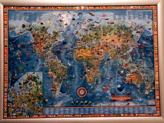
Rare maps and prints displayed at Mohatta Palace capture five centuries of cartographic history of the region. DESIGN: SAMRA AMIR
Those interested in history are in for a treat as rare maps and prints dating back to the 14th century are on display at the Mohatta Palace. They are set to be there till the end of the year.
The curators of the exhibitions brought together private collections and documents from the Sindh Archives. Many maps on display were the cumulative bequest of countless mariners, travellers, pilgrims, merchants, soldiers and administrators — from the days of the British Raj all the way up to Partition, who spent their lives exploring this part of the world. In total, there are around 90 rare maps and prints for the public to see and explore the past through.
The maps cover more than five hundred years of history and borders — from the date of the first printed map of the subcontinent in the 1480s, to the survey maps of the 1940s.

There are also maps which go back to 325 BC, when Alexander and his army travelled along the Indus from Chitral down to the Arabian Sea, and provided the first reliable topography of the coastline of Sindh and Balochistan. Within these parameters, the exhibition captures a five century old cartographic history of the region.
The maps and prints were divided into eleven sections, features included the seminal Decima Asie Tabula, first published in 1486, Map of Sind in AD 976 and AD 150, maps and prints from the Battle of Meeanee 1851 and James Rennel's 1788 Map of Hindoostan or The Mogul Empire.
In addition to these there are documentaries on the Silk Road and classical mapmakers whose efforts, ultimately bound up with ideas of status and power, did not simply represent the world — they imagined it and crafted it out of the ideas and needs of their age.
Curator Nasreen Askari told The Express Tribune, "We do a unique exercise every year and bring the most significant artifacts to the people." She said that the main sources for the displays were British museums, Sindh Archives, Jamia Millia and individuals such as Jamshed Marker and FS Aijazuddin, who is also a curator of Mohatta Palace.

"It took us three months to set it all up. This exhibition brings history and geography together," she said. "For several years, maps have plotted celestial bodies in the night skies, charted paths for transporting merchandise and detailed routes to guide travelers."
The exhibition also showcased maps from Afghanistan, Iran, Central Asia and China.
Drawing the line: Rare maps and prints will run from Tuesday to Sunday from 11am to 6pm till December 16.
Published in The Express Tribune, May 26th, 2014.







COMMENTS
Comments are moderated and generally will be posted if they are on-topic and not abusive.
For more information, please see our Comments FAQ