Careless lounging by the beach can harm turtle habitats
GIS mapping of habitats in Karachi uncover new trends and urgency for preservation.

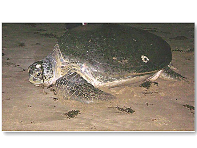
Garbage on beaches and construction debris from newly constructed or unused huts can deter nesting of Green Sea turtles (above). PICTURE COURTESY DEPARTMENT OF GEOGRAPHY, UNIVERSITY OF KARACHI
Recently, a project executed by the NGO Shehri-Citizens for a Better Environment made an effort to fill this information gap through digitised Geographic Information System (GIS)-based mapping. While general mapping was done of the coastal belt from Rehri Goth to Cape Mounze, an extensive data collection and mapping exercise was carried out in the Sandspit/Hawksbay turtle habitat area.

It is globally acknowledged that protection of sea turtle nesting sites is critical for ensuring survival of the specie for if nesting habitats are irreversibly damaged, there won’t be any specie left to protect. Due to various human activities, the Sandspit/Hawksbay habitat is severely threatened.
Violation of use of land has been observed by beach front development in the form of beach huts as a number of huts exceed the limits of legally allowed land usage. Consequently, space for turtle nesting is severely restricted. The beaches often contain large amounts of litter, which attracts predators like dogs, crows/gulls that then pose a direct threat to the turtle eggs/hatchlings. Construction debris on the beaches from newly constructed or unused huts can alter the sand characteristics, deter nesting attempts and interfere with the incubation of eggs and emergence of hatchlings. Sand excavated during the process also damages the beach as well as the sand habitat.
Nesting interrupted
In the project, the successful and unsuccessful nesting sites were marked and related with data on mean sand depth, beach access (obstructions to nesting access such as huts) and potential predation sources. This helped in analysing and identifying causes and locations of hindrances to turtle nesting.
The beaches are one of the most visited and important turtle nesting sites in the world for the Green Sea Turtle (Chelonia mydas) and Olive Ridley (Lepidochelys olivacea). Most important of all data layers were the themes which are affecting the turtle nests. Turtle nests from 2005 to 2009 were mapped with the help of HRS data. Having an area of 13,120 square metre and length of 780 metre, the entire stretch of the beach is approximately nine kilometre. It was found that 52% of the entire documented nests along the 9km beach strip were located on the 0.78km sand bar. Legally covered area is 68,813 sq m while the area of actual constructed structure is 189,148 sq m. As such, the area of extended encroached space, through car park or fencing, comes out to be 256689 sq m. The beach huts number 823.
Usable data
Data generated during the project clearly indicates that the Sand Bar Platform, because of its specific physical and natural characteristics, provides the highest level of suitability for turtle nesting.
Some key characteristics such as soil composition, ground water level, slope and gradient and high water mark have been studied and their linkages established with turtle nesting. Possible linkages with the changing coastal and wave dynamics were also considered, with recommendations that detailed field studies and analysis be initiated to study this phenomenon.
The survival of the specie is linked to the protection and sustainable development of its habitat that would require continued and detailed monitoring of the physical and natural landscape and human influences as well as appropriate planning to facilitate greater suitability of the habitat to, as is the case in our project area — nesting of green sea turtles. With regards to the documentation of the coastal eco-system other than the turtle habitat, the GIS Map should help through digitised documentation in deterring future non-environment friendly activities.
The writer is an urban planner and runs a non-profit organisation based in Karachi city focusing on urban sustainability issues. He can be reached at fanwar@sustainableinitiatives.org.pk
Published in The Express Tribune, October 21st, 2013.


COMMENTS
Comments are moderated and generally will be posted if they are on-topic and not abusive.
For more information, please see our Comments FAQ