Pm Shehbaz arrives in Turkiye on last leg of 3-nation tour
Updated 44 minutes ago
System continuously records, analyzes changes within forest areas using remote sensing technology

The Punjab government has introduced a province-wide satellite monitoring system for forests, marking a significant technological advancement in environmental governance. Officials describe the initiative as the first coordinated digital surveillance mechanism for forests in the province.
Senior Provincial Minister Marriyum Aurangzeb said the system has been rolled out under the directives of Chief Minister Maryam Nawaz Sharif. She explained that the platform integrates multiple high-resolution satellites, including WorldView-3, SPOT 6-7, Pleiades, PRSS-1, Landsat, and Sentinel-2. These satellites will provide real-time data on forest cover, tree health, vegetation patterns, and land-use changes, enabling authorities to detect illegal logging, encroachments, and other irregular activities with immediate precision. Alerts generated through live satellite feeds will be relayed to the Environmental Protection Force for prompt action on the ground.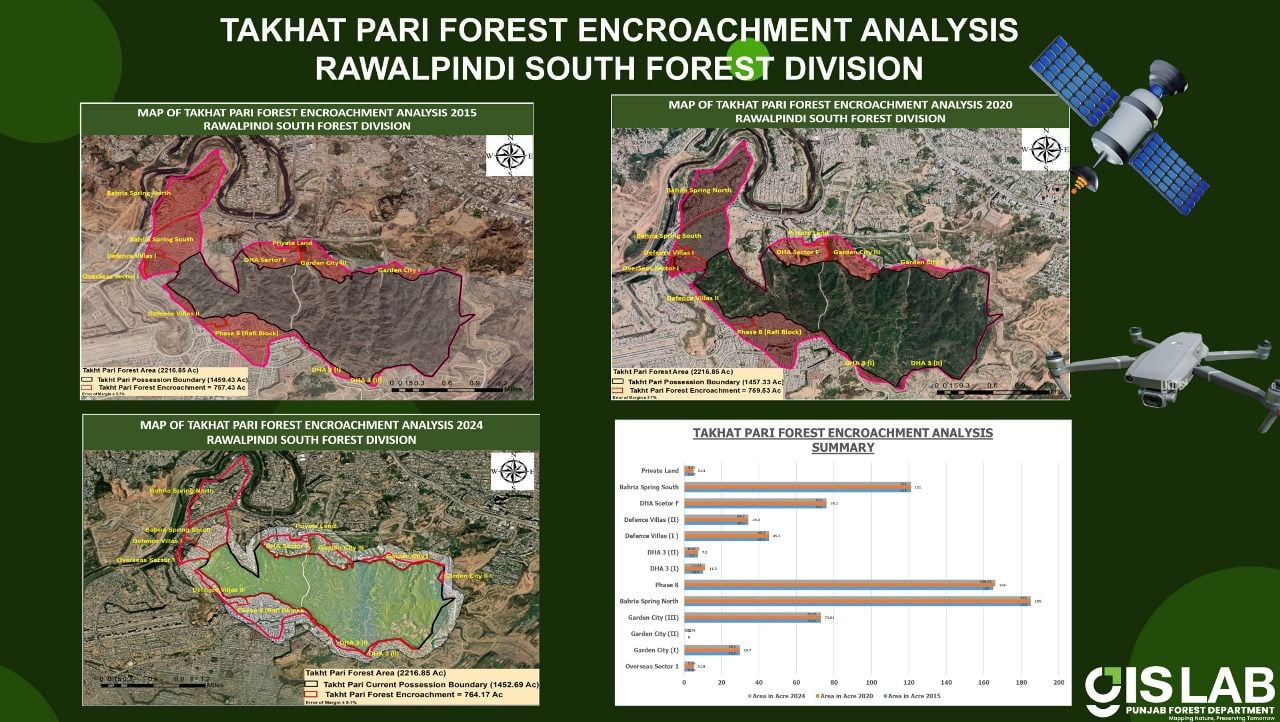
Aurangzeb highlighted that the satellite-based information will also support the planning of afforestation drives and wildlife conservation initiatives. Remote sensing technology will allow accurate assessments of environmental shifts, fire incidents, and associated losses, helping authorities respond more effectively to threats.
For the first time, the system will compile a comprehensive electronic record of forest land across Punjab. According to Aurangzeb, this digital archive will help prevent manipulation, encroachment, or unauthorized changes to forest boundaries. Satellite imagery will also assist in identifying optimal locations for future plantation campaigns, ensuring that upcoming afforestation efforts are more targeted and impactful.
Read: Deforestation fuels flood risks
Aurangzeb announced that the Punjab government is formally integrating the newly established satellite and drone-based forest monitoring system into the institutional structure of the Forest Department, ensuring that it will not be outsourced to any private entity. According to her, a centralized control room and an advanced Geographic Information System laboratory have been set up, both operated by highly trained technical staff. The unit will be included permanently under the sanctioned new establishment, keeping full administrative authority within the government.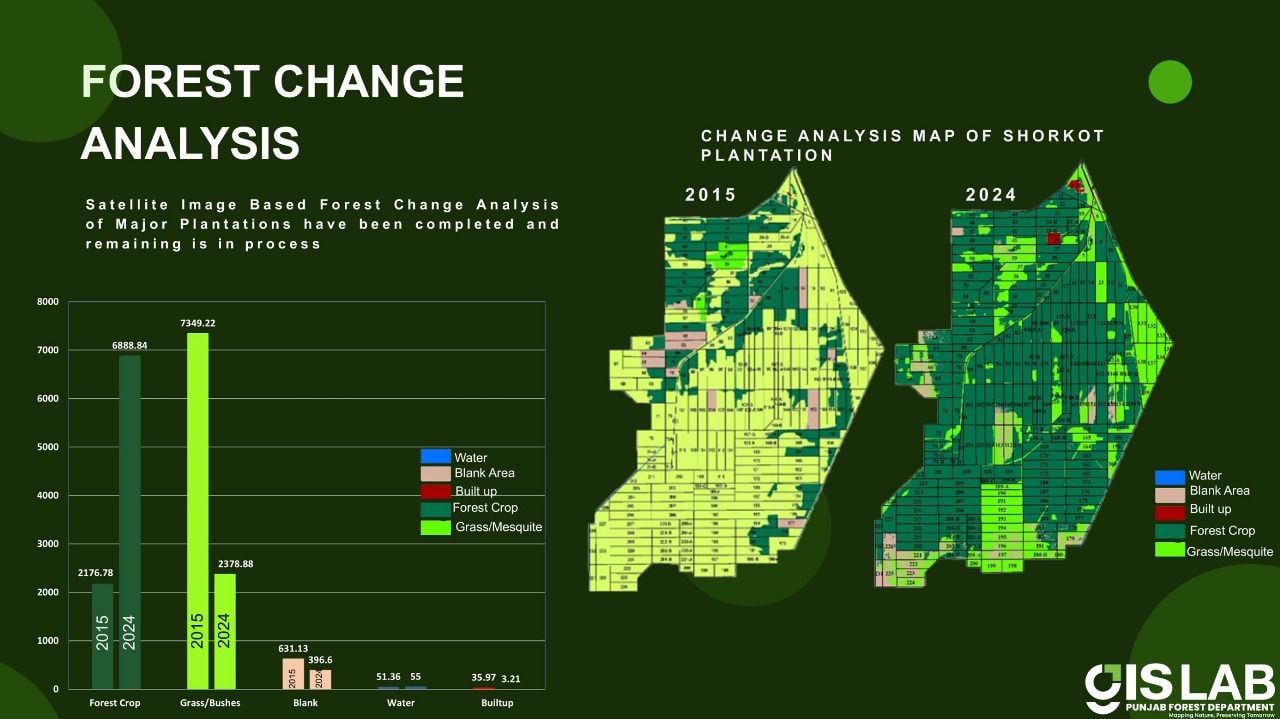
She stated that the success of this digital monitoring initiative will be assessed through specific performance indicators, particularly the effectiveness of automated reporting and digital oversight. The system continuously records and analyzes changes within forest areas using remote sensing technology and provides instant alerts on unauthorized activities or environmental disturbances, a feature that was not available in the past.
She further noted that the system operates autonomously, relying exclusively on satellite and drone data. It has been designed to be tamper-proof, ensuring that no individual or political actor can alter or manipulate the information. This, she said, guarantees the integrity, transparency, and objectivity of forest monitoring across the province.
The Government of Punjab is currently funding the project, and all technical personnel have been recruited through open competition. These professionals have received specialized training from several reputable national institutions to maintain high operational standards.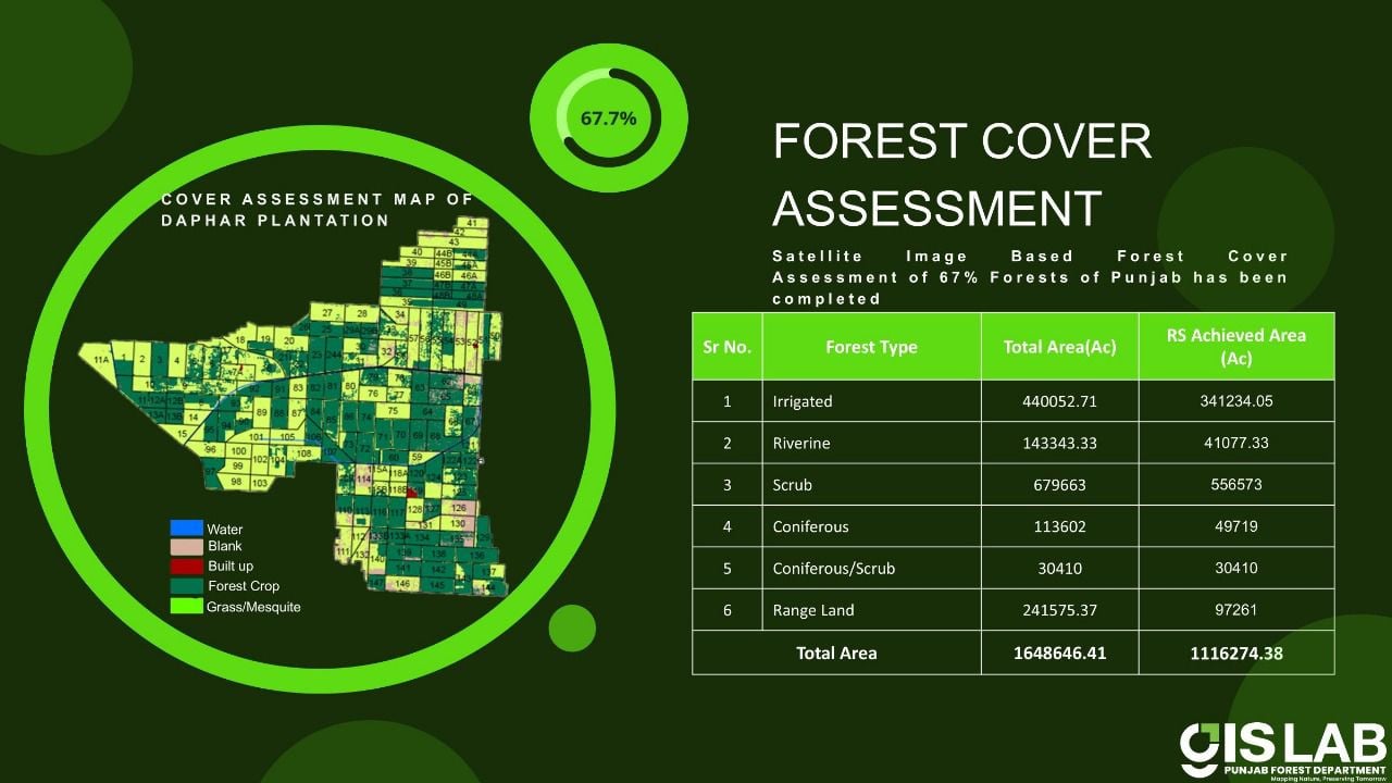


This material may not be published, broadcast, rewritten, redistributed or derived from. Unless otherwise stated, all content is copyrighted © 2026 The Express Tribune.


COMMENTS (1)
Comments are moderated and generally will be posted if they are on-topic and not abusive.
For more information, please see our Comments FAQ