Google, Apple maps indicate Russian invasion ahead of news going public
Open-source intelligence expert Jeffery Lewis and team were able to ascertain an invasion was underway in Ukraine
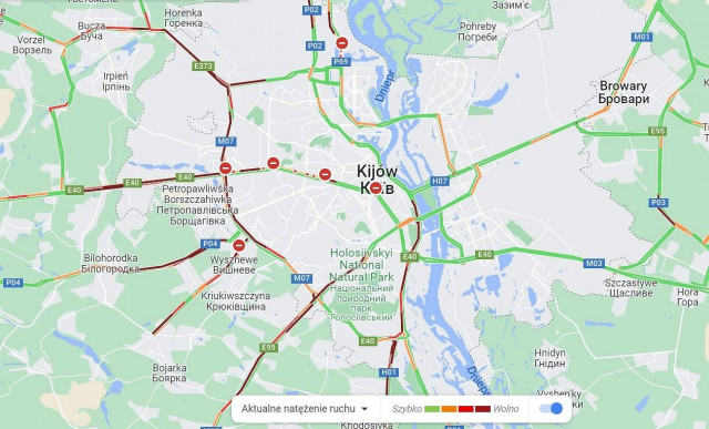
Open-source intelligence expert and professor at Middlebury Institute, Jeffery Lewis and his team were able to ascertain an invasion was underway in Ukraine before the information went public. Lewis and his team used Google Maps traffic information alongside a radar image that showed troops to understand the situation.
Lewis tweeted at 3:15 AM local time, that Google and Apple maps displayed a traffic jam in Belgorod, Russia to the Ukrainian border.
According @googlemaps, there is a "traffic jam" at 3:15 in the morning on the road from Belgorod, Russia to the Ukrainian border. It starts *exactly* where we saw a Russian formation of armor and IFV/APCs show up yesterday.
— Dr. Jeffrey Lewis (@ArmsControlWonk) February 24, 2022
Someone's on the move. pic.twitter.com/BYyc5YZsWL
In the tweet, Lewis noted that the traffic jam began at the exact position where a Russian formation of armor and IFV/APC had been reported. However, in a later tweet, he clarified to his followers that the traffic jam is detected by Google Maps was not soldiers carrying smartphones but civilians stuck at roadblocks. Lewis and his team had been using optical and radar satellite imagery to get evidence of Russian armored and heavy vehicles lined up and ready. His team noticed the traffic jam on the application after they received satellite images from Capella Space.
Google did not respond to Lewis's observations and how Google was capturing live traffic data while tipping off the exact location of the oncoming military invasion. Lewis said, "I think big data companies often don’t want to face squarely how useful their data can be. I mean, it’s cool when we do it, right? It’s maybe less cool if the Russians were able to do something similar to, you know, spot an offensive from Ukrainians.”
This raises the issue about the accidental power of tech, creating a clash between civil rights, civilian-oriented technology, and security.





COMMENTS
Comments are moderated and generally will be posted if they are on-topic and not abusive.
For more information, please see our Comments FAQ