Footprints in the mud
Taking the road less travelled to the Chandragup volcanoes, a hidden geological wonder off the coast of Makran.

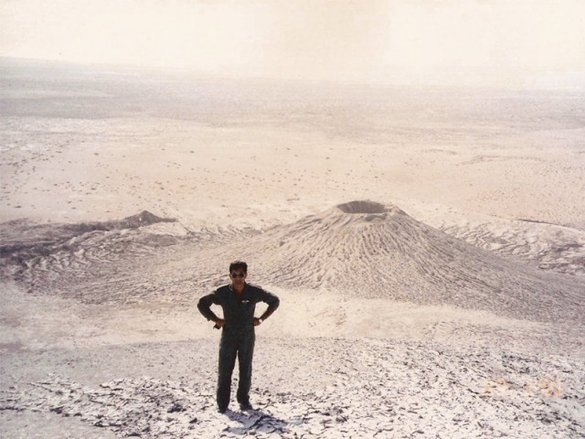
Taking the road less travelled to the Chandragup volcanoes, a hidden geological wonder off the coast of Makran. PHOTO: Kaiser Tufail and G.Gonsalves
Suddenly the earth started shaking and the shallow waters near the shore began to froth. Huge hillocks on the ground which were previously silent now seemed to be the centre of strange activity as whitish rivers of mud began cascading down their sides. All of a sudden, there was a huge explosion at the centre of one of the hills and a ball of fire burst into the night!

The next day it became clear that the Makran subduction zone (a region of the Earth’s crust where tectonic plates meet), just off the coast of present day Pakistan, had experienced major seismic activity. The quake shook the Manora lighthouse so violently that two pounds of liquid Mercury, upon which the heavy lighthouse lamp usually floats, spilled out. The shock waves created a tsunami and more than 4,000 people died from the combined effects of the earthquake and the tsunami. Soon news began to appear about the appearance of three new islands in the Arabian Sea.
It was surmised that the explosion and fireball witnessed by the RAF pilots was from the mud volcanoes of Hingol. The earthquake had shaken and vented the volcanoes, which had ignited and started spewing mud. Mud volcanoes form in places where pockets of underground gas force their way to the surface. Because they are not caused by magma, the mud volcanoes, rather than being hot, can be very cold. Pakistan has a number of mud volcanoes in the Makran Desert and offshore. While most mud volcanoes are usually less than 3-7 feet tall, Pakistan’s Chandragup Mud Volcano is more than 300 feet high.
RAF officer Peter Martin-Kaye, deeply intrigued by the events, decided to visit the volcanoes with a friend to study them first hand. They made the journey from Karachi to Hingol and back, on foot, camelback, bus and sailboats, and observed some tall mud volcanoes in the Liari area as well as visiting the Chandargup Mud Volcanoes near Koh Sapat.
He documented and photographed the entire journey in his war-time diary. After WWII, RAF officer Peter Martin-Kaye went on to become Dr. Peter Martin-Kaye. With a PhD in geology, Martin-Kaye led several ground-breaking projects for the United Nations and NASA. More than half a century later, I got hold of a copy of his diary and traced him. Unfortunately, before I could make a request for photographs he passed away.

Decades after Martin-Kaye’s visit, Kaiser Tufail, a pilot in the Pakistan Airforce was similarly captivated by the strange activity in Chandargup. He visited the sites and did some preliminary studies on the subject. I recently got in touch with Tufail, now a retired Air Commodore, and he generously permitted me to use his notes and pictures.
Chronology of famous Eruptions
The mud volcanoes of Pakistan have been active since time immemorial. The mud islands created during 1945 quake were washed away by strong monsoon currents and tidal activity within months of their creation. On March 15, 1999, an extrusion started again in the same area at a depth of 10 meters and created a similar island. It was named Malan Island. At the time, the local media reported that calls of “Allah-o-Akbar” had been heard amidst the roaring and rumbling as the island emerged from the depths. Whether these reports were true or not remains largely a matter of opinion. Nearby, on the coast of Makran, the Chandragup family of volcanoes are highly revered by Hindus and are considered an important part of their pilgrimage to Hinglaj Mata temple further inland along the Hingol River. Be it Hawaii, Japan, Indonesia, or Pakistan, we have always managed to find some association between powerful geological phenomenon and religion.
On November 26, 2010 approximately three kilometres from the coast off Hingol, an island suddenly surfaced from the bottom of the ocean. The island basked under the Pakistani media’s limelight and a team of National Institute of Oceanography visited the island for research purposes. However, all of Pakistan’s mud islands have so far met the same fate as the legendary Atlantis.

In my quest to discover more about these mysterious mud islands, I requested the Pakistani space research organisation for a satellite picture of the island and that of the 1999 Malan island. I already had a copy of this, which was published in a research paper of the time, but I was not surprised by their reply. They claimed that they could not find the 1999 picture and would not grant me right of usage for the copy in my possession. However, they told me that I could purchase a low resolution black and white image of the recently emerged island from them for Rs15,000 per picture. Dejected, I tried a long shot and made a similar request to NASA. I was shocked at their prompt response. They said that due to the satellites orbit and image capturing schedules I’d have to wait weeks before my request could be complied. A few months down the road, I was delighted to be informed that they had uploaded high resolution coloured images that I had requested, for public usage!
Directions and Hazards — A Road less travelled
The most accessible mud volcanoes on the Makran Range are the Chandargup family. In order to get there, one has to take a left from the Makran Coastal Highway (MCH), approximately 35 kilometres before the Aghore post at river Hingol. The area lies within the limits of the Hingol National Park and the management has erected a concrete sign to mark the path to the mud volcanoes, the largest of which is visible from the highway. The path is a series of dirt tracks which are only navigable in a 4x4 vehicle. Initially, we had considered trekking the 10 kilometre track from the MCH to Chandargup and back again. The idea was abandoned after we were told about the sand flies. These tiny, winged gnats seek exposed skin and their bites leave large, red itchy bumps that may turn into a rash. Sandflies are known to carry a host of viruses and people are known to have died from complications arising from sand fly bites. It is strongly recommended that all would-be adventurists proceed when they are completely prepared as far as vehicles, equipment and physical condition is concerned. The area is completely isolated from civilisation and the chances of any rescue are virtually zero. Cell phones are also useless as there are no signals for more than 50 kilometres in any direction.
While the hazards might put you off the journey, the view from the top of the volcano makes the effort well worth it. The 300ft high peak provides an excellent vantage point for viewing both the coastal highway and the Arabian Sea, which is barely 5 kilometres away. As it was not the peak activity season, when we visited, the discharge of mud was low but there was visible moisture and mud on the surface of the crater. A flag or two, some coconut shells, a few plastic bottles, blackened make-shift stoves and some dried up tire tracks in the parched mud were the only reminders of the Hindu pilgrims and adventurists who visit the site.
Mud volcanoes hold clues to our underground mineral resources, not to mention important geological and seismic information. They are also a potential tourist attraction not only for the Hindu devotees but also for any adventure junkie. Their formation and scientific studies carried out in the area, have proved the presence of huge deposits of methane underneath the surface. Unfortunately, the gas deposits are in a solid form called methane hydrates. Science has not yet figured out a way of extracting methane from this form in a controlled manner. Perhaps in the future, the mud volcanoes might answer Pakistan’s energy needs.
Published in The Express Tribune, Sunday Magazine, February 24th, 2013.
Like Express Tribune Magazine on Facebook to stay informed and join the conversation.


COMMENTS
Comments are moderated and generally will be posted if they are on-topic and not abusive.
For more information, please see our Comments FAQ