To help climate migrants, Bangladesh takes back land from the sea
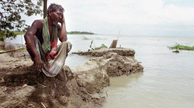
River erosion alone claims about 20,000 acres of land in Bangladesh every year

Over the next 20 years Bangladesh hopes to reclaim a total of 10,000 square kilometres of land. PHOTO: AFP
Climate change-linked natural disasters are common in Bangladesh, with cyclones and storm surges displacing huge numbers of people.
"River erosion alone claims about 20,000 acres of land in Bangladesh every year," said Water Resources Minister Anisul Islam Mahmud.
That leaves up to 200,000 people homeless each year, according to a 2013 study by the Refugee and Migratory Movements Research Unit at the University of Dhaka and the Sussex Centre for Migration Research at the University of Sussex in Britain.
Now Bangladesh is taking back some of that land. The government plans to use the natural movement of sediment through the country's rivers to build new land on which to house displaced communities.
In June, the government signed a deal with the government of the Netherlands - another low-lying nation - to cooperate on land reclamation efforts. Under the partnership, the Netherlands will conduct a feasibility study, and develop and implement land reclamation programmes in Bangladesh.
Bangladesh's three major rivers - the Padma, the Brahmaputra and the Meghna - carry large amounts of silt with their water.
According to a study by the Dhaka-based Center for Environmental and Geographic Information Services (CEGIS), about 1 billion tonnes of silt flow through the country's river channels every year, most of it eventually settling in the southern coastal area of the Bay of Bengal.
According to Malik Khan, the CEGIS deputy executive director, if sediment can be directed into low-lying areas of the coastal Noakhali district through a system of cross dams - walls constructed between islands - and polders - land surrounded by embankments - new land will emerge from the sea.
"There is a potential for land reclamation through the displacement of the sediment the rivers carry," he said.
Cross dams catch sediment as it travels downstream, holding it back before it reaches the Bay of Bengal. As it collects behind the dams, sediment can build up into solid landmasses large enough to live on, experts say.
Read: How will climate change affect your livelihood?
Zahirul Haque Khan, director of the Coast, Port and Estuary Division at the Dhaka-based Institute of Water Modelling (IWM), notes that many small islands, called chars, have already emerged naturally in the coastal areas near Nijhum Dwip and Monpura islands.
With the tide bringing large sediment deposits to the areas around Urir Char in Noakhali and Sandwip in the Chittagong district, hundreds of square kilometres of land could be reclaimed from those areas through the construction of cross dams, he said.
Learning from the past
Bangladesh has worked for over two decades to reclaim land from the sea. One of the first systematic efforts to study the potential for land reclamation was the Netherlands-supported Land Reclamation Project launched in 1977.
Since then, the Bangladesh Water Development Board has carried out a number of projects using cross dams to accelerate the build-up of land, several with support from the Netherlands. As a result, the country has so far reclaimed over 1,000 square kilometres of land from the sea south of Noakhali.
Inspired by the construction of the Bestin cross dam, a project which was completed in 2010 and connects Char Montaz with Char Khalifa in Noakhali District, the World Bank is now carrying out studies on the possibility of connecting Urir Char and Noakhali using a cross dam.
Read: Global insecurity and refugee crisis linked to climate change: expert
In addition the government has identified 18 other potential cross dams to accelerate the building of land at the coast. Together they could help reclaim about 600 square kilometres of new land, said M. Shamsuddoha, the director engineer with the Bangladesh Water Development Board.
The government has not yet said what the project would cost. Government officials have declined to give an estimate, instead saying they hope to add to the country's own funds with donor support and by encouraging private companies to promote tourism and set up industries on the reclaimed land.
Over the next 20 years Bangladesh hopes to reclaim a total of 10,000 square kilometres of land, according to Water Resources Minister Anisul Islam Mahmud.
"As siltation is a natural process in the Meghna estuary, (a cross dam) would be a cost-effective way to reclaim land from the sea to help deal with migration and rehabilitate climate victims," he said.
And if sea level continues to rise at its current rate, the numbers of families needing new homes in Bangladesh will escalate, experts say.
According to the Intergovernmental Panel on Climate Change, global sea levels could rise by as much as 98 centimeters (more than 3 feet) by 2100. And a 2012 report by Unnayan Onneshan, a Bangladesh think-tank, states that sea level rise in Bangladesh's coastal region could exceed that estimate and hit one meter by 2100.
That would affect 25,000 square kilometre of land (17.5 percent of the country's total land) and displace an estimated 31.5 million people, the report said.
"Bangladesh is experiencing adverse impacts of climate change," said Khan of the CEGIS. "Land reclamation would being a good solution in dealing with future climate migrant crises."


COMMENTS
Comments are moderated and generally will be posted if they are on-topic and not abusive.
For more information, please see our Comments FAQ