In epic sweep, Sindh’s land records computerised, service centres opening
Papers linked to digital version, maps and history of transactions
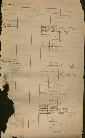
A scanned page of a Property Register the British created in Hyderabad in the 1920s. Image courtesy: Larmis
A mind-blowing 15 million pages of land ownership records, which form 90% of Sindh’s entire inventory, have been scanned, indexed and computerised in a project that could change an entire culture of bribery and corruption.
This database and access to its records are available free for the public at three out of 27 district service centres in Sindh so far. By the end of this week the number will rise to eight when the Peoples Service Centres open at Hyderabad, Karachi (Malir), Karachi (Central), Thatta, Tando Mohammad Khan, Badin, Matiari and Jamshoro. The rest will open by December.

This epic undertaking, better known as Larmis or the Land Administration and Revenue Management Information System, is six terra bytes large, making it the world’s largest database in Sindhi. And the man running the show, Zulfiqar Shah, is sitting on what law-enforcement agencies and the Supreme Court know to be the solution to half of Karachi’s crime, to say the least.
 This is a sample of a printed copy of a land record with the computerised information matching the old scanned record in Larmis. Note the security features. PHOTO COURTESY: LARMIS
The most unbureaucrat-like Shah, a soft-spoken but resolute 45-year-old who studied at Indiana University, is a Grade 20 officer from Nawabshah and was the DCO of Naushahroferoze before he was put in charge of Larmis in 2011. The project was kickstarted by a presidential directive to the Sindh government in September that year, with orders to computerise the land records in consultation with Nadra. By December more backing came from the Supreme Court that ordered all four provinces to do the same thing.
Read: Technological advancement: Sindh police to computerise crime records
It was because of this pressure and mandate that Shah was able to get done in three and a half years a job that usually takes at least 10 years in the region. What is more, he has done it at a cost of Rs4.9 billion entirely funded by the Government of Sindh. Punjab’s computerisation is costing Rs15 billion and the World Bank is paying for it. “The objective [of Larmis] is to eliminate tampering of records,” he explains. This is achieved by minimising a point of contact with revenue officials, which is why the linchpin of the project is moving from a localised system (available in only certain locations) to a centralized database that will be available across the province.

The problem with the old system is that it was fragmented. Land ownership documents were physically divided between the offices of the Mukhtiarkar, the department of Survey and Settlement and sub-registrars. “Fragmentation is the basic reason why tampering takes place,” says Shah. Manipulation happens in isolation. Larmis ends this. “This is an age of central databases and zero clients,” Shah adds. “The beauty of a centralised system is that you get a record from anywhere of anywhere. The management should be decentralized, databases should not.”

In simpler terms, look at the current system. In Sindh, each of the districts keeps physical land records at Mukhtiarkar offices. If, say, you live in Larkana and own lands there, you have to go to the mukhtiarkar to ask for your record. He pulls it out of the land register and gives you a “true” copy with his signature. If you wanted a bank loan, you would have to go back and forth between him and the bank. Larmis plans to end all of this dancing around and the culture of bribes to get the work done. The new system is biometric. If you come to access the record of land you own, the revenue staff will take your photo and verify your biometrics with your original ID card through Nadra’s system. The manual paper record will be linked to a digital record with an audit trail. “We will keep a trail of document requests,” says Shah. “Every property document will be logged.” So you can tell if a district commissioner has made any changes to your land ownership papers. Plus, the copies Larmis will give you will have security features with seals, watermarks, strips and bar codes to make them easier to track in hard copy as well.
Read: What’s the plan?: The EA’s design for the Green Line
What has been computerised
When the British conquered Sindh in 1843, the first thing they did was survey what they had. First they drew district boundaries, then taulka boundaries and then the smallest unit or deh boundaries. Today Sindh has 6,000 dehs, 123 taulkas and 29 districts.
These great geographers and cartographers, the British, then assigned survey numbers within dehs. A survey number works like your home plot address number. A farmer in Malir, for example, owns survey numbers 542, 540, 539. So survey No 542 is a patch of land. Each survey number can be a maximum of 16 acres large. But note that one survey number, just like say your ancestral grandfather’s house, can have multiple owners. So there is no direct corelation between number of survey numbers and number of land owners.

All of these surveys and survey numbers were written down in Land Registers (also called Village Form 1). Today the Land Register is under the purview of the Department of Survey and Settlement. The Land Register tells you, for example, that a deh has 5,000 acres out of which 2,000 are mountains, 2,000 are flat land, 500 are a graveyard and so on. Larmis has scanned all these Land Registers but because they are hand-written text documents, their entries are being matched to all of the available maps (some deh maps are missing) and Larmis’s own GIS maps of the province. Indeed, Karachi is the first division of the country, says Shah, which has its own digital GIS survey.
The British came up with 18 forms or types of records for land ownership, many of which are not in use today. Of interest to Larmis have been village forms 7 and 2. Village Form 7 will contain all the details of the land ownership and transactions (buying, selling etc) for agricultural land. Village Form 2 is for non-agricultural land. This kind of paperwork is kept at the Mukhtiarkar’s office. Larmis has also scanned property cards, which are kind of like library cards. If you own a piece of property it will have a property card.

The first time you acquire land it is written in Village Form 7A. If there is any “mutation” or transaction on your land, that is all recorded in Village Form 7B. This form shows the transfers from owner to owner with details of the previous owner always given. And while it is perfectly normal for a piece of land to have several mutations, or changed hands eight to 10 times, the problem is when fraud is embedded in any one transaction. Shah says that it is possible to trace it but it is a cumbersome undertaking from manual paper records. Larmis attempts to make this easier when you have an entire database of survey numbers as an investigative tool.
The sytem becomes slightly more detailed when you turn to Karachi. The British created a City Survey prior to Partition. They did this for Karachi and other major cities in the province. For Karachi, they named 28 quarters which exist till today (Saddar, Martin, Lyari quarters). They kept Property Registers for these quarters, which Larmis is today computerising. These records are in English but Shah says that the writing can be hard to read.
Karachi presented a particular problem in the sense that while most of the city had land records and survey numbers, vast tracts were undocumented especially in the suburbs. Karachi’s 18 land-owning agencies have their own land management systems but Larmis has gone a step further and allotted survey numbers to the blank spots. This closes an important gap. “What would happen is that the government would allot someone 4 acres but they’d sit on 12 acres,” says Shah, referring to the lack of survey numbers in certain areas. “Under the Supreme Court orders, new survey numbers were made with satellite coordinates rather than stone fixtures.” Larmis has colour coded them to tell the difference.
Larmis is also connecting the survey number to the land record which allows revenue staff to go to a digital map, click on Survey No 562 and see the land record pop up along with the history of land transactions on it.
Much of this work is informed by a visit in 2014 that Shah and other officials made to India with the World Bank to study models developed in Andhra Pradesh, Delhi and Karnataka, one of the pioneers of land record computerization. In Karnataka, not only have they computerized their land records but they have also started public service e-Seva centres, which have spread across the country now. “You can get your domicile, your birth certificate, all your municipal services at them,” says Shah. “They have created a big data of government documentation which is conveniently available to the people at a very low cost and with a considerable level of convenience and dignity.” At the e-Seva centres, you get in line, pull out a token, wait for your number. “One of the concepts I liked in particular,” says Shah, “were the villages kiosks [for these services] just like an Easyload ki dukaan. It is pro-people.”
The process of making the database
In three and a half years, Larmis scanned and indexed all of Sindh’s land records (except the ones burnt after Benazir Bhutto’s assassination, see box). The work was contracted out and five labs were set up, one in each divisional headquarter. “We asked the deputy commissioners to produce the record and get it scanned the same day,” says Shah. The contractor had German Bookeye scanners which scan one page per second. You just need to keep turning the page.

After all the scanning was done, nine firms undertook the data entry from the scanned images. “To do this job, [the firms] needed 1,000 people who could read and write Sindhi, were IT literate and who were willing to work for a short period of time,” says Shah. These nine firms went through the Institute of Business Administration to ensure that the staff was recruited on merit after independent testing. Additionally, the chief minister sanctioned similar hiring of 108 new Larmis staff for the peoples service centres.
Once the data was entered, there were third-party software checks by Sidat Hyder Morshed Associates (Pvt) Ltd to maintain the integrity of the process. Once the data was entered, prints were sent back to the district for verification. The data entry firm will be publishing the records in triplicate and calling for objections in each union council. Those that are not objected to will be notified. “In developed countries, governments take ownership and guarantee the credibility of [such documentation],” says Shah. Unless our government adopts this people will not be able to trust investing in land.
Once the verified prints come back their final data is stored in the centre and all of this is backed up in a disaster recovery centre located in Hyderabad which is expected to be up and running by October. If, for some reason the Karachi nerve centre falters, Hyderabad will take over.
The challenges
As was to be expected, the existing paper land records are not complete. Shah estimates that 60% of them are marred by inherent flaws that have accumulated over the ages. The Larmis template needs to be filled but many times certain variables are missing. If you own 10 acres of land which each have 10 survey numbers, for example, the computer will ask for the area for all 10. But if a survey number is missing on your paper record you won’t be able to fill that blank box. Your record will still be rolled out but will be marked incomplete.
In addition to facing this infuriating problem, Larmis had to work around the fact that Sindh’s land records are in Sindhi. This is a peculiarity of the province because the records of other provinces are in Urdu. When the British were surveying Sindh they decided that it was best to keep the records in the language that locals understood. “The difficulty is that you have to develop a system from scratch because it is linguistically different,” says Shah. So each form needs a different software in Sindhi language because their formats are different.
The British had passed on another problem for Larmis—by being, well, British and excrutiatingly thorough. No other province has as many forms for land records as Sindh’s 18. “The British wanted to colonise Sindh so they mapped its canals, distributaries, barrages,” says Shah. They didn’t leave a single stone unturned. They left us with an extraordinary bank of maps and paper records that cover the province’s entire geography, and all of that has to be digitised.
Hand-in-hand with the computerisation of the land records has been the GIS mapping. The maps are georeferenced so no one can mess with them. Previously, land was measured with a Gunter’s Chain, an engineering instrument with 100 links, and stones or pegs marked boundaries. But if someone picked up the stone, your land marker would be gone. The mapping with coordinates also protects land owners from corruption in Larmis because anyone can use them to prove what they own.
A lot more legal homework needs to be done to protect the system. The Sindh Land Revenue Act has been amended, for example, to provide legality to electronic documents. With changes to the Electronic Transactions Ord, 2002, they will be able to prosecute anyone who manipulates a land record.
What the database yields
Perhaps the most important achievement by Larmis is that the government can now tell what it owns or its assets. It is hardly surprising that the Supreme Court, National Accountability Bueau and other government agencies have relied on it. Larmis told the SC that 60,000 acres of land in Karachi were encroached on, out of which 52,000 acres were by institutions, the provincial and federal governments.

Once the system is integrated for land records and the automation of stamps and registration, the government will also be able to tell what has been the impact on revenue streams as well. Given that the entire system worked manually, with computerisation it will be easier to apply for, say, an agricultural loan. With the land bank, banks and financial institutions will find their work a lot easier. Larmis creates collateral used to generate economic activity.
Aside from these more immediate uses, Larmis can generate a treasure trove of socio-economic information on Sindh. There were no statistics, for example, on how many landowners existed in the province. Shah can now tell you that Sindh has 35 million acres out of which 10 million are owned by mainly private entities. The rest is state land. He can tell you how much katcha land runs along the river Indus. Also, 90% of land owners in Sindh possess less than four acres—information that could be an important policy making statistic. Similarly helpful is the fact that for the last five years CNICs were needed for all land transactions, so Shah has five years of data. So he can tell, for example that women’s land ownership has gone up from 15% to 22%. But as with all statistics, he cautions that the land ownership may not necessarily reflect the ground reality. But for whatever it is worth, Larmis is still a gamechanger for the province.
Reconstruction: Phoenix from the flames of post-BB burnings
After Benazir Bhutto was assassinated, fires broke out across Sindh. The rumours were that the land ownership records were burnt for the entire province. The truth is, however, that only those of 887 dehs out of 6,000 were burned, according to Zulfiqar Shah of Larmis. “It was mainly arson but is also suspected that the record was only partially damaged and they made it disappear,” he told The Express Tribune. Arson completely burned the records of Naushahro-Feroze, taluka Mehrabpur. Thatta also suffered as did Jamshoro. The good news is that the records are being reconstructed. Nearly 600 dehs have been done. A committee is working under a retired member of the Board of Revenue, Nazar Mohammad Leghari, who Shah says is a man of “well known integrity”. Village Forms 7A and B are being summoned from people and other sources and they are being checked and cross checked. Open katchehries are being held in every deh as well.
Published in The Express Tribune, August 7th, 2015.










COMMENTS (14)
Comments are moderated and generally will be posted if they are on-topic and not abusive.
For more information, please see our Comments FAQ