Recycling urban spaces: Need for strategic thinking to revitalise the old, not build more
KRC can draw inspiration from NYC’s High Line which has been redesigned as greenway.
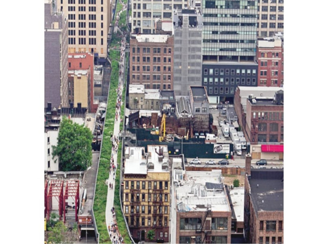
The High Line, an elevated park on top of an abandoned railway track, weaves its way through New York City’s blocks. It has become one of the most popular public spaces in the city with its picturesque views perhaps being the biggest draw. PHOTO COURTESY FARHAN ANWAR
We are now in the age of strategic urban planning, where as far as possible, the focus is on making use of what you have by revitalising abandoned and blighted spaces rather than plan for grandiose projects - a legacy of the master plan age.
A classic example of ‘strategic planning approach’ in practice is the New York City 2030 Plan. There, decision makers and planners decided that they need to envision what they would like New York City to look like in 2030 and created PlaNYC as a bold agenda to meet these challenges and build a greener, greater New York. Although not exactly coming out of the PlaNYC, but following its guiding principles of community mobilisation, building of partnerships and focusing on revitalising decaying urban spaces, has been the High Line project- a 1.6-km New York City linear park built on a 2.33 km section of the elevated former New York Central Railroad spur called the West Side Line. It has been redesigned and planted as an aerial greenway.

Prior to its transformation, the line was in a state of complete disrepair and during the Giuliani administration, it was slated for demolition. In 1999, however, area residents Joshua David and Robert Hammond started a community group, Friends of the High Line, dedicated to turning the High Line into an elevated park. In 2002, the Bloomberg Administration backed the project and it became a reality in the year 2006.
According to the Projects for Public Spaces, the High Line is accessible by foot (via stairs or an elevator), public transportation, and automobile. It is conveniently located near a number of subway stops and is surrounded by major thoroughfares that permit vehicular travel. Visitors can enter at a number of different locations.
The High Line has become one of the most popular public spaces in the city. Its picturesque views are perhaps its biggest draw along with a number of public art installations. Under the elevated park is ‘the Lot,’ a temporary public plaza featuring food trucks.
What Karachi can learn
The High Line makes one wonder if perhaps we could do the same in Karachi. In 1964, the Karachi Circular Railway (KCR) opened a 26.56-km section between Drigh Road and Wazir Mansion and was extended from Wazir Mansion to Karachi City in 1970. At its peak in 1984, it carried more than 6,000,000 passengers annually.

The operational efficiency of the KCR, however, was marginalised and its ridership dwindled with every passing day beyond the year 1985 and was eventually closed to traffic in January 2000. Since October 2004, however, when the then the prime minister constituted a task force to study the existing KCR network and formulate recommendations/proposals for its revival or otherwise, a process has been ongoing, funded by the Japanese government to make this project materialise.
Still a dream but since it’s still in the planning space, would it not be a good idea to take some inspiration from the High Line project — though not totally compatible (High line being grade separated and KCR being on grade) — and add an element of ‘transit oriented land use development’ in the larger planning framework.

In route of the Karachi Circular Railway are large tracts of government land that can be used to develop ‘housing schemes’ for the low income community. SOURCE: SPECIAL ASSISTANCE FOR PROJECT FORMATION FOR KCR
For example, in route of the KCR are large tracts of government land that can be used to develop ‘housing schemes’ for the low income community. Karachi is suffering immensely from ill-planned urban sprawl and needs vertical densification with the accompanying social and environmental safeguards. KCR can help facilitate that. Similarly, potential can be analysed for other forms of land use development having recreational and commercial aspects along with an urban revival of the localities en route the KCR so that the project goes beyond just providing a public transport service but helps facilitate urban revitalisation and appropriate transit oriented development.
What we need are visionaries and also committed citizen activists and hope for a Friends of the KCR taking shape.
The writer is an urban planner and runs a non-profit organisation based in Karachi city focusing on urban sustainability issues. He can be reached at fanwar@sustainableinitiatives.org.pk
Published in The Express Tribune, December 16th, 2013.







COMMENTS
Comments are moderated and generally will be posted if they are on-topic and not abusive.
For more information, please see our Comments FAQ