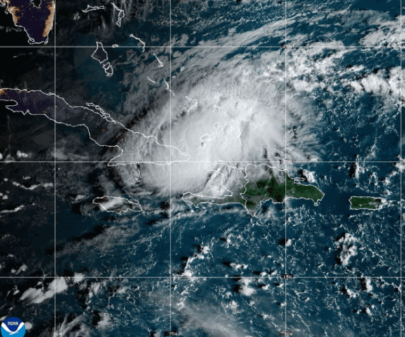
Hurricane Oscar classified as Category 1, poised to impact Cuba this evening
The latest NHC advisory says Oscar is moving toward the west-southwest near 12 mph

Hurricane Oscar is approaching Cuba as the island nation grapples with restoring power after a massive nationwide blackout that lasted for days.
The storm's expected arrival on Sunday, just days after the failure of Cuba’s largest power plant severely impacted the national grid, adds further pressure to a country already facing inflation along with shortages of food, medicine, fuel, and water.
Hurricane Oscar has been classified as a Category 1 storm due to its sustained wind speed. According to the National Hurricane Center (NHC), an 8 a.m. EDT advisory indicates that the storm is expected to continue a west-southwestward or westward motion at a slower forward speed through tonight. A turn toward the northwest and north is anticipated on Monday and Tuesday.
As of Sunday morning, Oscar's center was located 115 miles east-northeast of Guantanamo, Cuba, moving west-southwest at approximately 12 mph. The storm is forecasted to cross Great Inagua this morning and make landfall along Cuba's northeastern coast later today.
Following its landfall, Oscar is expected to accelerate northeastward across the central Bahamas on Tuesday. Maximum sustained winds are estimated at 80 mph, with higher gusts possible.
Expected Impacts from Hurricane Oscar
Wind: Hurricane conditions are likely to persist across the warning area in the southeastern Bahamas, particularly on Great Inagua Island, through this morning. In Cuba, hurricane conditions are expected to develop later this afternoon and evening. Tropical storm conditions may affect the warning area and potentially the watch area in Cuba through Monday. In contrast, tropical storm conditions will begin to diminish across the Turks and Caicos Islands this morning.
Rainfall: Eastern Cuba may receive rainfall amounts ranging from 5 to 10 inches, with isolated totals of up to 15 inches. The southeastern Bahamas could see 2 to 4 inches, with isolated amounts reaching around 6 inches. For detailed rainfall forecasts, please refer to the National Weather Service's Storm Total Rainfall Graphic.
Storm Surge: A dangerous storm surge is forecasted to cause significant coastal flooding on Great Inagua Island, where water levels may rise 2 to 4 feet above normal. In areas along the north shore of Cuba with onshore winds, water levels could reach 1 to 3 feet above normal tide levels, accompanied by large and destructive waves.
Current Status of Hurricane Oscar
- Location: 115 miles east-northeast of Guantanamo, Cuba
- Maximum Sustained Winds: 80 mph
- Movement: West at 12 mph
- Minimum Central Pressure: 986 millibars
A minimum central pressure above 979 mb may indicate minimal damage potential. However, it can also suggest future storm intensity changes, with a drop in pressure typically indicating strengthening.
Understanding the Cone of Uncertainty
The NHC’s cone of uncertainty illustrates possible paths for Oscar's center. It's crucial to remember that the storm’s impacts may extend beyond this cone, as storm tracks can veer outside the expected range about a third of the time.
Watches and Warnings Summary
- Hurricane Warning: In effect for southeastern Bahamas and the north coast of Cuba from Holguin and Guantanamo to Punta Maisi.
- Hurricane Watch: In effect for the north coast of Las Tunas, Cuba.
- Tropical Storm Warning: In effect for Turks and Caicos Islands, the south coast of Guantanamo, and the north coast of Las Tunas.
- Tropical Storm Watch: In effect for the north coast of Camaguey, Cuba.
A Hurricane Warning signifies that hurricane conditions are expected within the area, and preparations should be completed urgently. A Hurricane Watch indicates possible hurricane conditions, typically issued 48 hours before the anticipated onset of tropical-storm-force winds.
For localized storm information, individuals are advised to monitor updates from their national meteorological service as Oscar progresses.
4o min


COMMENTS
Comments are moderated and generally will be posted if they are on-topic and not abusive.
For more information, please see our Comments FAQ