
NASA's Visible Infrared Imaging Radiometer Suite (VIIRS) has been instrumental in revealing the extent of destruction from Israel's recent bombing campaign in Lebanon. Satellite data, particularly from NASA's Active Fire 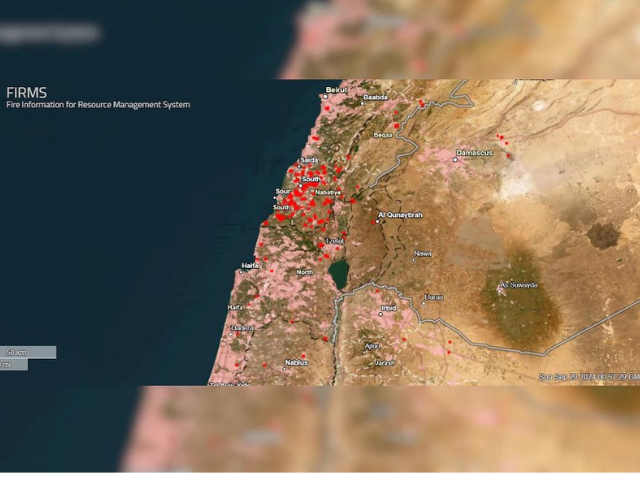
Map, has detected numerous heat signatures across southern Lebanon, confirming intense airstrikes that have significantly impacted the region.
Amidst this backdrop, Israel escalated its military operations, resulting in the targeted killing of Hezbollah leader Hassan Nasrallah. The Israeli Defense Forces (IDF) confirmed the airstrikes that occurred over the weekend, which also affected the capital, Beirut, where Nasrallah was killed along with several senior commanders.
Prime Minister Benjamin Netanyahu declared that Israel has "settled the score" with Nasrallah, following a week of sustained aerial bombardments aimed at dismantling Hezbollah's military infrastructure.
The IDF has focused its strikes on southern Lebanon, where it believes the bulk of Hezbollah's military capabilities reside, while also targeting supply routes along the Lebanon-Syria border to disrupt arms shipments from Iran.
Despite Israeli warnings for civilians to evacuate, many airstrikes have been directed at urban settlements, resulting in significant casualties. Over 1,000 people have reportedly died in the bombardments, the deadliest escalation since Lebanon's civil war. Satellite data has highlighted the strategic precision of these attacks, underscoring the ongoing conflict's severe humanitarian impact as tensions between Israel and Hezbollah continue to rise.
1719315628-0/BeFunky-collage-(8)1719315628-0-405x300.webp "article")


1731329418-0/BeFunky-collage-(39)1731329418-0-165x106.webp "article")


1731821450-0/Untitled-design-(17)1731821450-0-270x192.webp "mysterious doomsday fish washes up on california beach")
1731822323-0/Copy-of-Untitled-(4)1731822323-0-270x192.webp "bluesky s rise why users are migrating from x")


1727606146-0/BeFunk_§_-(96)1727606146-0.jpg "kashmiris protest assassination of hezbollah leader hassan nasrallah")


COMMENTS
Comments are moderated and generally will be posted if they are on-topic and not abusive.
For more information, please see our Comments FAQ