Hidden borders of 'mysterious' continent Zealandia finally revealed
We're only just starting to discover Zealandia's secrets, says scientist Dr Derya
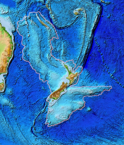
Scientists are mapping the mysterious "lost" continent of Zealandia — which was discovered in 2017 — for the first time. The gigantic landmass in the South Pacific disappeared beneath the waves 23 million years ago.
It was originally part of the gigantic super-continent Gondwana, which was made up of continents which now exist in the southern hemisphere.
Covering 1.9 million square miles, Zealandia is six times larger than than Madagascar, the next-largest continental fragment.
It extends from south of New Zealand northward to New Caledonia and west to the Kenn Plateau off Australia's east coast.
About 94 per cent of the landmass is underwater.
The "hidden" continent is now being partially mapped thanks to a deepwater mapping expedition led by The University of Queensland, The Sun reported.
Chief scientist Dr Derya Gürer spent 28 days at sea on Schmidt Ocean Institute’s research vessel Falkor, exploring the north-western edge of the continent.
"We’re only just starting to discover Zealandia’s secrets," Dr Gürer said. "It’s remained hidden in plain sight until recently and is notoriously difficult to study."
Radar scans carried out by the team explored the contours of the narrow connection between the Tasman and Coral Seas in the Cato Trough region – the narrow corridor between Australia and Zealandia.
In total, they have provided 14,00 square miles of topographical data to the Seabed 2030 project.
The project aims to produce a publicly available bathymetric map to measure the depth of the world's ocean floor depth by 2030.
Read more: Scientists discover new continent named 'Zealandia'
“The seafloor is full of clues for understanding the complex geologic history of both the Australian and Zealandian continental plates," Dr Gürer said.
“This data will also improve our understanding of the complex structure of the crust between the Australian and Zealandian plates. It’s thought to include several small continental fragments, or microcontinents, that were split from Australia and the supercontinent Gondwana in the past."
Zealandia is thought to have broken off from Gondwana between 85 and 79 million years ago.
The supercontinent encompassed what is today South America, Africa, Antarctica, Australia, Zealandia, Arabia and the Indian subcontinent.
By about 23 million years ago, it's thought that Zealandia was almost completely submerged in water.
Experts spent 20 years gathering data to make the case for the submerged landmass being a continent. Their efforts were frustrated because most of it is hidden beneath the waves.
The article originally appeared on The Sun












COMMENTS
Comments are moderated and generally will be posted if they are on-topic and not abusive.
For more information, please see our Comments FAQ