Lahore: Living on the edge
In the race to rival the world’s best developed cities, Lahore has marginalized some of its residents
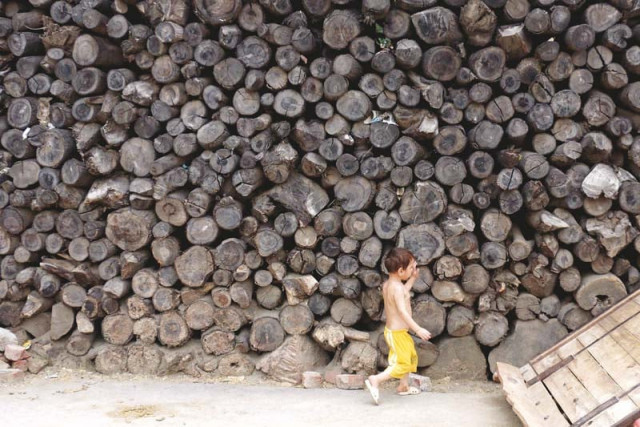
Various regimes have made periodic changes to the physical form of the city but today traces of Afghan, Turk, Hindu and Mughal interventions in Lahore are confined to the Old City. Even the transformations under colonial rule appear miniscule compared to the changes experienced by the citizens of the city in the last three decades. The new Lahore is an ever-expanding megalopolis. It is the second largest metropolitan city in Pakistan, home to more than 10 million people. Though much of Abul Fazal’s description from the 16th Century rings true in 2015, the city has transformed beyond recognition; so much so, that at times even those who were born here two decades ago cannot recognise the city they live in.

A girl walks down a narrow, unpaved street in Chungi Amer Sidhu. PHOTOS : SHAFIQ MALIK
Take Ahsan Bhatti, for example. The 23-year-old is a resident of Chungi Amer Sidhu, a working class neighbourhood south-east of Lahore. What is known as ‘Chungi Amer Sidhu’ to the urban Lahori today was known as Chindrai village, which was not even a suburb of Lahore, up until the 1990s. At that time, Model Town marked the end of Lahore’s boundaries.
“The society at the time was mostly feudal,” explains Bhatti. “Three families — the Jutts, Bhattis and Joiyas — owned most of the land.” He says Chindrai was far enough from Lahore to have a toll tax booth between the two places. “It was all farmland here, with rice, wheat and cotton being the main produce,” Bhatti adds. Till this time, the villagers of Chindrai had led a serene life, mostly unaware that the fate of their village was tied to an urban sprawl unfolding in the metropolitan city a few kilometres away.
Rural to urban sprawl
According to the Integrated Master Plan of Lahore 2021, Lahore grew along 10 radial traffic arteries with an urbanisation rate of 49% over a period of two decades. Each urban corridor along these traffic arteries can be distinguished from the other in terms of its functions, morphology, mode of transport and the type of commuters that traverse it. Chungi Amer Sidhu falls along Ferozepur Road, which carries the bulk of the traffic, along with Raiwind and Multan Roads.

Behind Ferozepur Road’s new infrastructure lie neighbourhoods with unpaved streets, open sewers and families of workers who commute across the city to work. PHOTOS : SHAFIQ MALIK
Industrial concentrations had emerged on the outskirts of Lahore in the south-west as early as 1965. Quaid-i-Azam Industrial Estate, which has the claim of being the oldest planned industrial and urban housing estate in the country, was among the first that began attracting rural labour to industries around Lahore.
The estate had 477 industrial plots of various sizes varying from one kanal to 100 kanals. Today, textile, dyeing and printing, auto parts, pharmaceuticals, food, household appliances, plastic, chemicals, rubber and cosmetics industries are part of the estate. According to the Quaid-i-Azam Industrial Estate website, some 50,000 workers (including 10,000 female workers) are employed here.
In 1994, the Punjab Small Industries Corporation opened along the Lahore-Kasur Road and offered 304 plots between 1 to 2 kanals. Industries that emerged here processed pharmaceuticals, soft drinks, leather and other consumer goods. The Housing and Physical Planning Department also set up an industrial estate where 245 plots were designated for large- and medium-sized industries. Besides these major industrial zones, unplanned low-tech industries also began to mushroom unchecked.
These industrial concentrations in the south-west of the city brought pollution and migration — factors that accelerated the rural-urban transition in Chindrai. Waste from industrial estates, and housing schemes attached to them, began choking water works around Rohi Nala for agricultural land on the south-east side. “This was an area where development had been left untouched because of the general proximity to the border with India,” says Dr Mohammad A Qadeer, author of Third World: Internal Dynamics of Lahore and Pakistan: Cultural and Social Transformations in a Muslim Nation while talking to The Express Tribune.

An overhead bridge for motorbike riders and cyclists on Ferozepur Road. PHOTOS : SHAFIQ MALIK
Ahsan Bhatti recalls that each year plastic bags choked the fields and crop yield declined. Farmers then started selling off land and morphed into private developers as farms became less sustainable. It became more profitable to cater to the housing needs of the incoming labour.
Azra Shaheen, a 50-year-old resident of Amer Sidhu, laughs as she describes how the first urban housing in Chindrai emerged. “They would mark plots with tapes, leave a few feet between them for a street and sell them off,” she recalls.
This trend, according to the Integrated Master Plan of Lahore 2021, can be explained by two factors: land speculation and the repeal of the Land Acquisition Act. Between 1947 and 1985, land development schemes had been mostly undertaken by the Lahore Development Authority and its predecessor, the Lahore Improvement Trust. Collectively, they developed some 97,000 plots. The Housing and Physical Planning Department also provided 5,000 plots of three marlas.
Since land was mostly held in the private sector, land acquisition was imperative for land development. In 1976, the Punjab Acquisition of Land (Housing) Act was enacted to enable the LDA to set up housing schemes by acquiring land at the cost of Rs100,000 per hectare (Rs40,000 per acre). However, it was repealed in 1985 and the Land Acquisition Act 1894 was restored, which required payment at one year’s average market rate. This carried heavy financial outlays for land acquisition for housing. It starved out the LDA, which then restricted its activities to ongoing projects. There was a definitive shift from the public to the private sector taking the lead in housing initiatives.

A girl walks down a narrow, unpaved street in Chungi Amer Sidhu. PHOTOS : SHAFIQ MALIK
Similarly, based on inter-census population growth rates between 1972 and 1998, it was believed that some 30,000 units would be needed just to take care of the population’s basic housing needs. On the supply side, there were some 2,500 plots in the formal housing market, a large number of which were held by speculators, creating further distortions in the market. The gap between supply and demand resulted in the illegal division of agricultural land around Ferozepur Road and Haridke Road in the south-east where these farmers-turned-private developers built flats and colonies to accommodate as much of the influx as they could.
“In developed countries, both the farm produce and farm sizes are increasing because of bigger and more efficient farm machinery and tractors; and as a consequence, the rural population is decreasing because it gets pulled into the city due to better employment opportunities,” notes Anisur Rehman in The Imperatives of Urban and Regional Planning: Concepts and Case Studies from the Developing World. He adds that in developing countries, farm sizes are becoming smaller and are uneconomic to sustain the newly formed families. Thus, the farm produce per unit of land is decreasing, and people are being pushed out from rural fringes into the cities.
Urban reality
Dr Qadeer refers to this phenomenon as the emergence of New Indigenous Communities (NICs). “[They] follow social and architectural idioms of the old city but with the infusion of some new design ideas,” he explains. “They have wide streets to accommodate modern vehicles but the same mohalla-like social and physical structure. The main streets are lined with shops and the side streets are residential. Many a times, these communities evolve out of existing villages but newer parts are laid out by some land entrepreneur.” In such cases, the land developer is a local businessman who hires a draftsman to divide land into small plots that are sold.

Ahsan Bhatti, a resident of Chungi Amer Sidhu, has initiated an awami bethak to mobilise residents. PHOTOS : SHAFIQ MALIK
“One clue to this form of new development is that its layout has some geometrical pattern: grids divided by crosscutting streets, but straight,” Dr Qadeer explains. “The planners make rudimentary provisions for drains and street alignment, but leave the rest to the buyers, who have to get together and lobby the city to extend them the services and regularise their colony.”
This is exactly what happened in Amer Sidhu. The entrepreneurial role and responsibility for the community was taken on by the Bhattis, who, as a result, amassed some political influence in the area. “My grandfather established Bhatti Colony and later, Bhatti flats,” Ahsan says. In 1997, the first sewerage system was installed when MPA Noor Muhammad Bhatti brought the issue to the notice of Chief Minister Shahbaz Sharif, when the sewerage system in Model Town was being upgraded.
In 2002, councillors under the local government system widened streets and renovated them. Ex-councillor Ghulam Hussain Bhatti says the streets were getting so congested, it was getting difficult to access them. He says that from 2002 to 2008, local governments were issued funds on proposals addressing urgent issues in their union councils. The local government in UC 137 (now 229) secured funds to set up the first school there. This school, called Elementary College, now offers a mix of middle school and high school education. Girls come here for Bachelor’s studies but most of the students are boys in middle school. There are no public primary schools in Amer Sidhu, but there are some 30 private schools operating from homes.
Hussain says he drew up the neighbourhood’s first master plan. He says roads were marked for improvement and plans for restructuring Amer Sidhu had been made. He says the local government set up tube wells and revamped Mujahid Road and Millat Road and turned the area into a commercial zone. “A plot in this area was worth Rs50,000 per marla in 1999,” he says. “After commercialising this zone, property prices went up to Rs700,000 or Rs800,000 per marla.”

Residents of Amer Sidhu complain about clogged drains in their area. They say they have polluted waterworks that are never cleaned by the authorities. PHOTOS : SHAFIQ MALIK
After the provincial government announced plans to install a rapid bus transit system in 2012, Ferozepur Road underwent immense transformations. Massive flyovers were built, roads widened and encroachments along this zone cleared. But behind these new structures are neighbourhoods with narrow, unmetalled streets, open sewers and families of workers who commute across the city to work.
“Access to safe drinking water is the biggest problem here,” says Ahsan. “The population keeps growing along the periphery of the neighbourhood and they are far away from water sources.” Garbage disposal and water drainage during the monsoon is another issue. “Amer Sidhu is a low-laying area. Water accumulation during the rainy season is a perpetual problem,” he says.
Residents of Amer Sidhu staged a series of demonstrations in 2010 when the neighbourhood was flooded during the rains. “We blocked Ferozepur Road and told policemen that we were peaceful but that we would not move until water was cleared from our doorsteps,” says Ahsan. He says WASA’s water tanks cleaned out the area within a few hours.
Grassroots mobilisation
The upkeep of Amer Sidhu is currently under the LDA’s ambit. Through its subsidiary bodies Water and Sanitation Agency (WASA) and Traffic Engineering and Transport Planning Agency (TEPA), the LDA manages water and sanitation, and transport planning.
“The LDA recognised the need for zoning around the Amer Sidhu area when the master plan was drawn up,” says LDA Metropolitan Planning director Shakeel Anjum Minhas. He says that to make up for the haphazard division of land in the previous three decades, the LDA has marked land for use in the future, but will wait for private developers for housing initiatives.
Meanwhile, he says, the subsidiary bodies of the LDA operating in densely populated parts of Amer Sidhu are handling the residents’ pressing issues. This, residents say, is not enough to make their neighbourhood more livable. They have pinned their hopes on the local government polls scheduled to be held in September this year. Local governments have not functioned in seven years.
Ahsan Bhatti has initiated an awami bethak in collaboration with the Community Support Concern and Umeed-i-Jawan, hoping to mobilise people to exert political pressure to obtain basic services.
His bethak has a cafeteria, a lounge and a small common room that serves as a dining hall. One of the walls is covered with portraits of renowned personalities and inspirational quotes. One can spot the faces of Faiz Ahmed Faiz, Che Guevara, Abdul Sattar Edhi, Mao Zedong, Nelson Mandela, Bulle Shah, Malala Yousafzai and Saadat Hassan Manto speaking on collective action, education, feminism, love and much more. The bethak also has a library stocked with an eclectic collection on history, politics and current affairs. The works of Habib Jalib, Benazir Bhutto and W.H Moreland occupy the shelves and the library is equipped with two computers, printing and comfortable couches.
Here, Ahsan helps organise lectures, debates, cricket tournaments and documentary screenings. The space attracts young workers employed on contract at various industries in the industrial zone around Kot Lakhpat. In the absence of recreation spots, this bethak is quickly becoming a popular spot for locals in the area. Bhatti has twice screened a documentary on Malala Yousafzai since the bethak opened March this year. He has been able to organise two debate contests between schools in the area and weekly lectures are held for workers on various issues. When summer vacations started, children began visiting the bethak to do their homework. One of the boys from the neighborhood uses this as a space for his dance lessons.
The bethak is just the first step towards political mobilisation. Recently, Ahsan announced that he would be running for local government polls in an alliance with Azra Shaheen and Murtaza Bajwa. All three are being backed by the Progressive Youth Front and the Awami Workers Party. “People on the ground are the best judges of the needs of the area,” Bhatti says. “If they cannot participate in policy decisions, they can at least point out priority areas.”
One doesn’t have to look too far beyond Lahore’s perimeters to see that as cities transform, the input of those on the ground is crucial. In July, residents of Afghan Basti in Islamabad’s I-11 sector, who had been living there for the last 20 to 25 years, were forcibly removed from their homes and the basti was razed to the ground. Ultimately, as Bhatti points out, if an ancient city like Lahore is to continue to evolve and transform into a world-class city, it must not render its poorest dwellers invisible.
Aima Khosa is a senior-subeditor at The Express Tribune and tweets @aimamk
Published in The Express Tribune, Sunday Magazine, August 9th, 2015.










COMMENTS
Comments are moderated and generally will be posted if they are on-topic and not abusive.
For more information, please see our Comments FAQ