River Indus flow to increase by 10%, pose serious threats in future: study
Climate models predict wetter South Asia in years to come

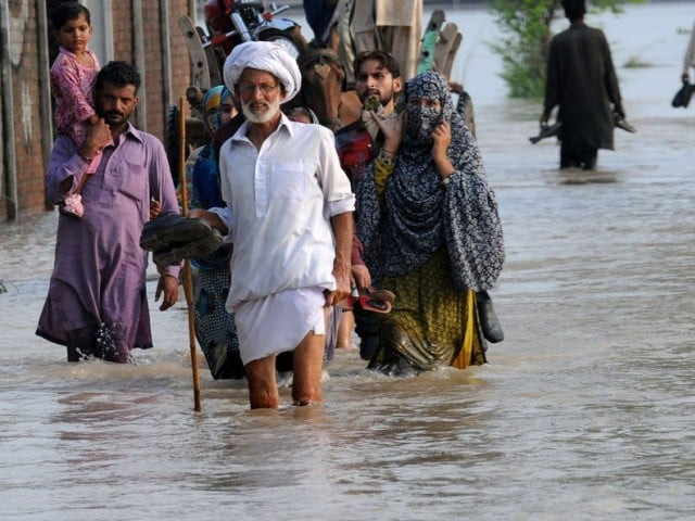
In this file photo, flood affected villagers walk through water in Murredke. PHOTO: AFP
A team of experts from the Commonwealth Scientific and Industrial Research Organisation (CSIRO) conducted a comprehensive baseline survey of the period 1976–2005 of all 54 rivers of South Asia and used this data in the climate models considered more accurate thus far.
As a result, the future predictions of a wetter South Asia are in consonant with the baseline study of the past. Global warming and climatic change – with more rainfall and enhanced temperatures – are responsible for the projected increase in water flow.
'Indus delta has shrunk by 92% since 1833'
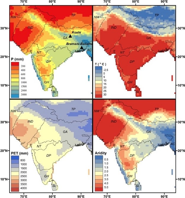
According to the research, flow of Indus, Ganges and Brahmputra rivers will increase by 10 to 30 per cent annual runoff according to the paper published earlier this month in the Journal of Hydrology: Regional Studies. The mean runoff will increase from 2046 to 2075.
The Ganges – Brahmaputra and Deccan plateau will see a 15 per cent spike in water flow, while 20 per cent increase is projected in Narmada – Tapti basin and Sri Lanka.
 PHOTO COURTESY: SCIENCEDIRECT.COM
The imminent increase in water flow of the rivers demands urgent need for a common platform for the South Asian countries to tackle the issue.
Challenges for Pakistan
An increase in River Indus flow even by a small percentage could pose serious challenges for Pakistan. The country’s experts have already warned that rainy period is decreasing in lower parts of the country and increasing in upper areas. Melting of glaciers, heat and evaporation will also lead to increase in flow of River Indus in the future.
Pakistan’s renowned climatologist and main author of the country’s first climate change policy, Dr Qamaruz Zaman Chaudhry says the study indicates increased flow of South Asian rivers, which is in consonant with previously held views of the experts.
“These projections demand scaling up of climate resilient integrated water resource management practices in the South Asia region, one of the most climate vulnerable region globally,” added Chaudhry.
95% of plastic polluting world's oceans come from just 10 rivers including Indus
Pakistan’s hugely populous districts are directly located in the possible flood regions and increased river flow will be a problem for these areas.
“Developing resilience in agriculture to regular climate shocks is one of the biggest challenges facing our region, as climate change will increase irregular rainfall patterns and increase incidence of floods and droughts,” Chaudhry said.
Scientists used different tools, satellite imagery and field work to collect the best data sets. Then the data was used in Coupled Model Intercomparison Project phase 5 (CMIP5) frame work with some downscaling for the South Asian region.
The CMIP was designed by hundreds of leading experts to predict future aspects of climate change. The first CMIP was devised in 1995 and still updating with more modifications. However, CSIRO experts also use other hydrological models too.


COMMENTS
Comments are moderated and generally will be posted if they are on-topic and not abusive.
For more information, please see our Comments FAQ