Take a look at the world's secret sites on Google Earth
However, a number of sites are still blurred out or hidden on Google Earth so that no one can view them

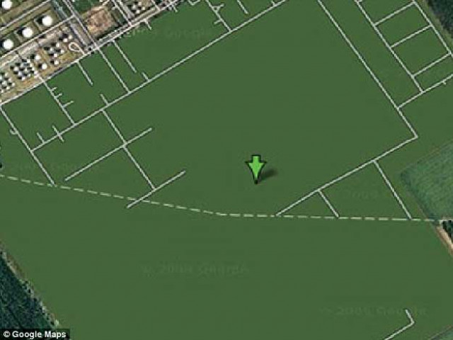
Picture shows tye area of Százhalombatta Oil Refinery in Hungary which has been wiped out from Google Earth.
There are a number of sites that Google wouldn’t show you on map that conspiracy theorists say are unidentified flying object (UFO) test areas. These sites are usually pixelated, or in some cases wiped out from the map completely.
Here is the list of all those sites which have somewhat disappeared from Google Earth, and no one exactly knows why:

Haarp site near Washington-Oregon border
High Frequency Active Auroral Research Program (Haarp) which was situated near the Washington-Oregon border was a research facility to study an energetic and active region of the upper atmosphere known as the ionosphere.
It was shut down by the US Air Force in 2014.
Many conspiracy theorists said that the facility was used to control the weather, or was a UFO site.
Even erstwhile president of Venezuela Hugo Chavez once said that Haarp caused the Haiti earthquake.
Adding more to this theory is the fact that the site is hidden on Google Earth.
Google Maps guides travellers offline

A concealed city in Russia
There is a large area in Russia specifically in the Siberian tundra that has been blurred out by Google.
One of the closes cities to this area is Egvekinot, Russia.
There are also other cities in Russia which doesn’t appear on the map provided by Google. Among them is Arzamas-16, home of the nuclear engineers who ended the United States’ nuclear monopoly.

Portlaoise Prison, Ireland
Ireland’s County Laois houses the Portlaoise Prison which is a high-security jail where country’s most dangerous criminals are put behind bars.
Although the place is not wiped out of the map, a closer look at the image suggests that the colours do not match with its surroundings.
This might mean that the area’s map has not been updated so that no one can plan to escape the prison.
Google gets a Star Wars makeover

The Faroe Islands, Denmark
The Faroe Islands, a self-governing archipelago, is basically a part of Denmark.
It is made up of 18 volcanic islands situated between Iceland and Norway in the North Atlantic Ocean.
A large part of the said area is pixelated including the old WWII military base of the Island of Vagar.
Again, no one knows why the area is hidden from viewers but some suggest that it is due to fishing rights.

Százhalombatta Oil Refinery in Hungary
Located in Hungary, Százhalombatta Oil Refinery had asked Google to be coloured green and had its buildings removed from the satellite images.

Kangtega, Nepal
Another site which has been blurred out on Google Earth is Kangeta in Nepal. It is a summit that rises up to 6,782 metres.
The reason for its disappearance from the map is again unknown but people suggest that it might be due to a glitch in the system.

The Volkel air base, the Netherlands
The Volkel site is camouflaged on Google Earth and there can be a few reasons for that.
The former Dutch prime minister Ruud Lubbers once said there were 22 US nuclear bombs stored in the bunkers of the said air base.
Also, nuclear weapons were stored at the base since the early 1960s and the Cuban missile crisis.

Keowee Dam, South Carolina
Ranging almost 26 miles long and three miles wide, having a depth of 54 feet, the Keowee Dam located on Lake Keowee in South Carolina has also been blurred by Google.
The dam provides hydroelectric power and is a crucial source for colling water for Oconee Nuclear Station (ONS).
But why would they want to hide it? No one know.

Valencia City, Philippines
Attributed often to an oversight on Google’s part, the Velencia city is wiped is pixelated on Google Earth.
The city which is a chunk of Philippines, houses more than 180,000 people.
It is also said that the city has headquarters of missile defence programme and therefore is pixelated for national security.
The article originally appeared on Daily Mail


COMMENTS
Comments are moderated and generally will be posted if they are on-topic and not abusive.
For more information, please see our Comments FAQ